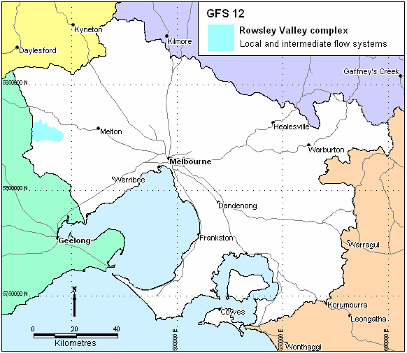
Region: Western PPWP CMA region
Type areas: Rowsley, Glenmore, Yaloak Vale
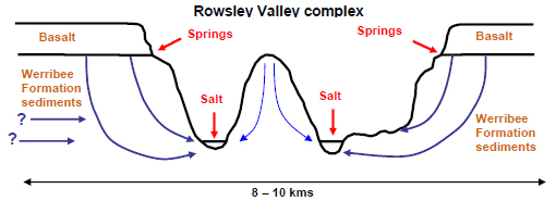
Brief description: The Rowsley or Parwan Valley is a large ‘bird’s foot’ valley incised into the Rowsley Fault scarp following uplift from the Pliocene to Recent. The Parwan and Yaloak creeks have cut through the basalts of the Newer Volcanics into the underlying Werribee Formation sediments. The rapid geomorphic development of the valley has resulted in some unusual landforms, including local mesas and isolated ridges. Landslides and erosion are features of the valley, resulting in significant areas of degraded land. The groundwater system of the valley is quite complex and a number of processes have been grouped together into one unique GFS.
Problem statement: Secondary salinity occurs in the valley floors and creek flats, probably as a result of land clearing and associated erosion of the valley floor. Spring discharge at the base of the basalt contributes to landslide processes and may contribute to the salinity. Groundwater in the Werribee Formation is probably confined by the boundaries of the Ballan Graben in which the valley is situated.
Geology: Ordovician Castlemaine Supergroup marine sediments of sandstones, siltstones, shale and chert (Ol, Olm). Permian fluvioglacial tillites of the Bacchus Marsh Formation (diamictites, sandstones, mudstones, conglomerates). Older Volcanic basalts (Tvo), Neogene alluvium (Tew, Tpb, Tpe, TRc) including the Werribee Formation, Brighton Group sediments and the Council Trench Formation. Quaternary alluvium (Qra, Qp2), colluvium and gully alluvium (Qrc), alluvial terraces (Qrt), lagoon and swamp deposits (Qrm), and Newer Volcanics basalts (Qvn) and scoria (Qvs).
Topography: Deeply incised undulating plain; steep slopes, isolated mesas and ridges, creek flats, undulating and hummocky low slopes, gorge.
Land Systems:
Central Victorian Uplands
2.1 West Victorian Dissected Uplands - Midlands
Western Victorian Volcanic Plains
7.1 Undulating Plains – Western District
Regolith: Highly variable. Unconsolidated cobbles, gravels, sands, silts and clays, weakly consolidated conglomerates, kaolin clay and sandy clay, ferruginised and silicified conglomerate and ironstone concretion boulders, thin bands of lignite, highly weathered basalt (sometimes with abundant calcium carbonate infill), scoria and pyroclastic sediments, palaeosols (sometimes with abundant pisoliths), and buried recent soil horizons.
Annual rainfall: 550 mm to 700 mm
Dominant mid-1800s vegetation type: Forest, Grassland and Woodland
Current dominant land uses: grazing, cropping, quarrying, educational and recreation facilities.
Mapping method: Outcrop geology
Aquifer type (porosity): Cobbles, gravels, sands, silts and clays (primary porosity), fractured basalt, ferruginised or silicified rock (secondary porosity).
Aquifer type (conditions): Unconfined, semi-confined to confined
Hydraulic Conductivity (lateral permeability): Variable and largely unknown. Probably from 10-2 m/d to 102 m/d.
Aquifer Transmissivity: Variable, but generally in the moderate range. Estimated to be generally less than 50 m2/d.
Aquifer Storativity: Variable. Estimated to be from 0.05 to 0.10
Hydraulic gradient: Highly variable, but generally associated with topography. Steep at the edges of the basalt, where springs occur. Moderate on the slopes and isolated ridges, low in the broad valley floors.
Flow length: Unknown. Possibly only a few metres to one kilometre in local systems, and up to 15 kilometres in the intermediate systems of the surrounding Werribee Formation.
Catchment size: Estimated to vary from very small (<1 Ha) in local systems to moderate (~ 5000 Ha) in intermediate systems.
Recharge estimate: Highly variable depending on location and aquifer type.
Temporal distribution of recharge: Seasonal (winter and spring) where exposed at the surface, with significantly more recharge in wetter years. May be continual steady recharge where overlain by volcanics.
Spatial distribution of recharge: Catchment wide on outcrops and extensive leakage from overlying basalt (GFS 20).
Aquifer uses: Minor use for stock watering?
Groundwater salinity (TDS): Variable in the range from 500 mg/L to 10,000 mg/L
Salt store: Moderate to high
Salinity occurrence: Valley floor and creek flats
Soil Salinity Rating: S1, S2
Salt export: Wash-off from surface and baseflow to streams
Salt impacts: Both on-site and off-site
Soil salinity hazard: Moderate
Water salinity hazard: Moderate
Assets at risk: Water quality of Werribee River (Melton Reservoir), agricultural land.
Responsiveness to land management: Complex. Needs varying solutions for different parts of the landscape. Should be high in local systems with short-path recharge-discharge.
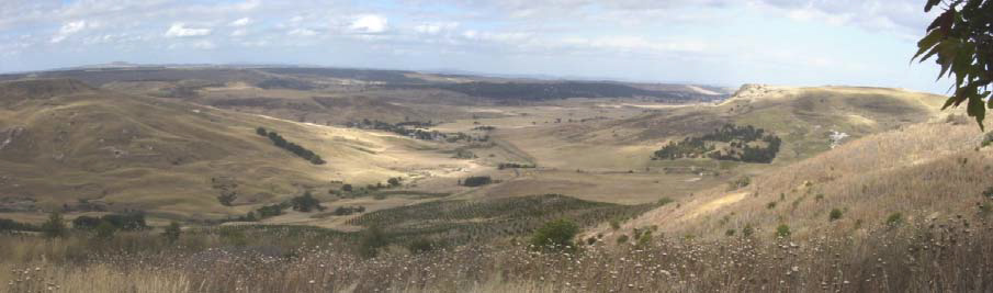
Panoramic view of the Rowsley Valley from Cut Hill, Yaloak
Salinity is a moderate issue in the Rowsley Valley. Practical salinity management is more likely where salinity discharge is related to internal valley local flow systems. However, intermediate (and perhaps regional) flow systems entering externally from the valley pose a greater challenge given the geographical extent of these systems. In these circumstances practicable salinity management will almost certainly revolve around stabilisation of discharge sites. Stabilisation of seeps is important to reduce the potential for landslips that emanate from spring zones along the base of the upper basalt cap.
| Options | Treatments | Comments |
|
Biological Management of recharge |
Perennial pastures | Moderate impact– especially for reducing recharge in in-valley local flow systems. More problematic for intermediate flow systems emanating external to the valley. |
|
Crop management | Low to moderate impact– for treating in-valley local flow systems and incorporating perennial pasture phase (e.g. lucerne) | |
| Trees/woody vegetation | Low to moderate impact– for treating in-valley local flow systems where trees can be incorporated into overall farming system to reduce gross recharge | |
|
Engineering intervention | Surface drainage | Low impact– disposal issues |
| Groundwater pumping | Low impact– cost and disposal issues | |
|
Productive uses of saline land and water | Salt tolerant pastures | Moderate to high– to stabilise and aesthetically improve salt affected areas |
| Halophytic vegetation | Low impact– climate and environs not likely to be conducive | |
| Saline aquaculture | Low impact– discharge sites only minor in extent | |
| Salt harvesting | Low impact– groundwater is not sufficiently saline | |
| Others | See OPUS database (NDSP) |
Management Implications Given Projected Land Use
The current land use regimes within and surrounding the valley are anticipated to continue into the near future, though there will be periodical fluctuation in the ratio of dryland grazing to cropping. Raised bed cropping (and any associated irrigation practices) may become a hydrological/drainage issue on the basaltic soils west of the valley.
Dahlhaus P.G., Heislers D.S., Brewin D., Leonard J.L., Dyson P.R. & Cherry D.P. (2004). Port Phillip and Westernport Groundwater Flow Systems. Port Phillip and Westernport Catchment Management Authority, Melbourne, Victoria.